 When traveling the Ontario and Western Railroad Rail to Trail you should use a mountain Bike in good working condition and possibly have a car to transport your bike.
 From my own experience, if you want to bike in the Catskills the cheap Walmart mountain bike probably won't last long.
I tried a Walmart Bike and the gears broke on the second trip. I have two Marin Mountainbike, my husband has got a Trek and other good bike brands are in my opinion for example Cannondale and GT. Although you can take a bike with you on the bus with Shortline, I recommend a car to transport your bike to protect your gears.

Some historical Facts about the Ontario and Western Railroad
I read in a historical railroad book that the reason for the Ontario and western Railroads decline had a lot to do with not having enough freight loads to make the railroad pay. To a lesser amount the decline in passenger was the reason for this railroad filling for bankruptcy in 1958. The Ontario and Western Railroad started in Jersey City but was also connected to New York.

First trip:
Liberty to Ferndale 5 Miles
I started my first trip at Liberty High School. Liberty High School is at Buckley Street in Liberty. I took Yaun Street down to Chestnut Street. When traveling on the trial through Liberty you will see on the pictures that follow,- you come by many buildings and storage units that were used by the Ontario and western Railroad in its days.


Things to see:

They have a nice pet store and a garden store in the proximity of the old station.

The train station burnt down and was replaced by this building. Along the route you will find more remnants of the Ontario and Western Railroad. The tracks ran to the left of the structure -- the view is looking toward Ferndale.

The structure below, also along the former tracks in the general area of the old stations is being used by the local power company for storage of transformers. The roofline and the color are the Ontario and Western original colors.


I can only guess about these building,- and that they were also used by the Railroad.


Nevertheless if you keep on following the road you will get eventually to the beginning of the OW Rail to Trail Track.


This path leads to the old Trestle. The trestle connecting Liberty to Ferndale was removed in 1962 to make place for the road to Swan Lake. I had to get of my bike three times because of trees that had fallen and were blocking the "O and W" trail. For hiking purposes this stretch of the woods is great.
In contrast to the parts of the path in Liberty i did not meet a single person, who was hiking or walking their dog like i did earlier on. It felt like i was walking a Fairytale path. And eventually I would reach the castle of Cinderella and Snowwhite. Likely a prince had taken this path earlier on....LOL
The trail then stopped abruptly after 1,5 Miles where the trestle used to be. I took the time and got of my bike and stepped on to the rim on the cement wall to peek down. You would have a great view if there weren't all these trees in the way.


These are pictures from postcards of the Ferndale-Liberty Trestle. I was standing on the remnants of the old trestle in the woods (see pic above) You can see more remnants (rectangular cement blocks) in the forest of the other side from the oil station after you hiked or biked up the hill on Station Hill Road.
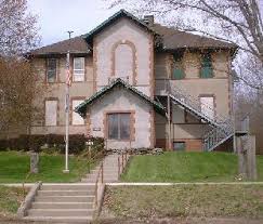
 After you roll your bike down the hill and get on Loomis street, you will have to pass Ferndale Road and bike up Station hill road. You will see left on top of the hill the old railroad station, which is now an Oil Station.
 If you are biking you will have to go right on Route 17 for 0.6 Miles and then take the first left on Twin bridge Road in order to get on the trail again. For the directions for getting on the trail to Hurleyville follow the directions below for the second Trip.

Things to see:
When you are nearly at the top of the hill you see to the left Country Petroleum Products. This was the old Ferndale Train Station. If you want to see where the trestle began walk past the the oil station and stand on the rim of the cement fortification which held the Trestle. You can see at the bottom of the hill on my pictures more rectangular cement piles. These are remnants of the trestle upon which the iron beams rested upon. Look at the second postcard and you can see the cement posts in use.

If you are hiking you can actually get back on the trail by walking Station Hill Road and go right past the building across from the old station.

Stay on the left of the building and at the end of the building you will see a stone that blocks a path between bushes. You can follow the path for 2 miles. This is the old Railway route, which I marked as Railbed. Pass the stone and you are on a big slope with electricity towers above you. Keep on going and you will walk below Camp Shane on the O and W path. Ignore the rubbish from Camp Shane and follow the path. You will come to a Canyon that is cut into the hill. At the end of the Canyon is a completely broken down construction trailer from 1958. This trailer was used by construction workers removing the rails and its remnants are still there...it's spooky.... Then you pass on the left the Property of a Farmer, his large fields and a Family cemetery. Do not get deterred and stay on the track sometimes you will have to move to the right of the path and eventually you will get to a company on Route 17. It makes sense to bring garden scissors for cutting some of the trees in the Canyon and trees and bushes at the end of the old railbed at Route 17.

The Company SMS, which is right next to the old O and W track has got an old Railroad Car standing on its original rails in the front. The refurbished Railroad car from the 40ies is painted with the SMS company Logo. SMS Metal's roof still has got the original O and W Colors, because it used to be an O and W building. Behind those trees are bushes, supposedly they were planted to seal of the entrance to the old railbed.
Be careful when crossing the road because of traffic. Across the road is U-Haul. The path used to go past U-Haul but is disconnected through the highway having been build. You should have to go left (i marked it as green line) on Route 17 until you get to Twin Bridge Road. Take a right on Twin Bridge Road and follow the directions of the second trip.
Second Trip:
Ferndale to Hurleyville 8 Miles
My first trip as a Camp Head Staff was to Hurleyville on the newly paved section for hiking and biking from Ferndale to Hurleyville. We got the trail at Old Monticello Road. In order to get on the still unpaved section of the trail you have to turn right on Twin Bridge Road and get on an unpaved section through the woods. It is possible to get on the section of the path earlier by going right at the second street right after Ross Electrics. You will have to carry you bike through some Ferns after crossing the Property. You can still see parts of the old rails like old wooden beams when you get around the curve. After you go for 2.5 Miles on this path you get to Denman Road, which you will cross. Now you are going directly to Hurleyville on a paved Section of the Ontario and Western. You pass the Mongaup River and left of you you see a big Pond.

I had arranged visit to the museum in Hurleyville, where you can see old household equipment, antique furniture, an exhibition on the hotels and its wildlife...and then we had low calorie Lunch at the Pickled Owl Restaurant in Hurleyville. Now, have been there twice and met an old german friend of my mothers with her American husband. Just recently they moved upstate. That day i ate a calorie bomb for dessert with whipped cream. I cannot recommend the Pickled Owl enough anything is very tasty even if it is low-calorie. Hurleyville also has a Farmer's market on Saturdays and a Movie theater that shows movies on the weekend.


From Hurleyville the O W continues to South Fallsburgh, NY and the paved rail trail begins behind Basketball courts. You are going for 2.5 Miles through a scenic marsh and then the east Mongaup River passes through the marsh. The wide trail gets narrower and passes through a rock cut. You pass eft by a white gate and then cross Westwood Drive at around 1.8 Miles. You will then head back into the woods along a moderate Berm. On your left you see Alta Lake and the path is gravel base, but is not maintained. You will then travel alongside a small pond and finally you will arrive in South Fallsburgh behind Basketball Courts.


Four Miles away from Fallsburg is the old Concord Hotel, which is now under development as a Racino. The site still has a huge Golf Course and the old Concord has been removed. This postcard shows the old Concord Hotel from the 50ies. Another idea for a trip is on this guys blog.
http://blog.russnelson.com/bicycling/1333289166.html
Third Trip:
South Fallsburg to Woodridge and from Woodridge to Mountain Dale 8 Miles.
 The old Railroad Bridge over the Mongaup River broke and they are currently repairing it or are going to repair it possibly until 2018. When this bridge is finally repaired the routes are going to be worth a marvelous day hike or you can even bike the O and W Rail to Trail by starting it in Liberty and ending it in Mountain Dale.
More info here: https://www.traillink.com/trail/o--w-rail-trail-/
Mountain Dale has got a wonderful bike shop where you can even rent a bike. They repaired my mountain bike tires and my gear for a price unheard of in New York City.
Things to see:
Close to Mountain Dale is Silver Lake.You can swim in Silver Lake. Mountain Dale also has got several cute stores and ice-cream parlors.
If you are interested in reading more about the development of rails to trail in Upstate New York and Governor Cuomos plan for 750 Miles bike and hike trails criss-crossing the State of New York.
https://www.gunkjournal.com/2017/07/27/news/1707271.html
No comments:
Post a Comment